Articles
What Makes a National Forest A National Forest? A Quick Guide to Public Lands
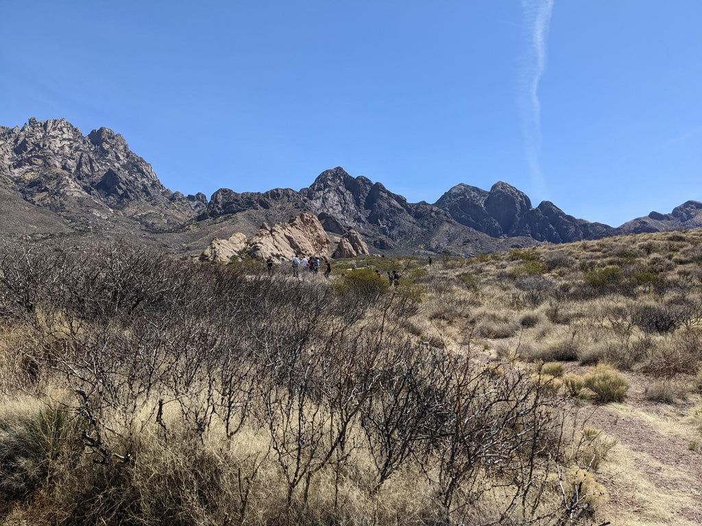
Photo: Organ Mountains-Desert Peaks National Monument.
Photo: Aspens in the Sandia Mountains above Albuquerque (Cibola National Forest, public domain).
What is a National Forest? What does the Forest Service do?
National Forests and Grasslands are any land administered by the U.S. Forest Service. These lands are managed under the multiple use mandate, a doctrine of land management that accounts for "multiple uses and benefits and for the sustained yield of renewable resources such as water, forage, wildlife, wood, and recreation."
Balanced use of resources was not always a priority, and at the time of its founding, the Forest Service was largely concerned with the material value of forest resources like timber, water, minerals, and grazing land for a country rapidly growing both in land area and population.
The U.S. Forest Service is a federal agency under the U.S. Department of Agriculture. Enacted in 1905, they were initially created to manage lumber and water resources of forested areas around the country. The National Forest idea came about (as with the other land management agencies) in a period of the late 1800s and the early 1900s when interest in conservation and appreciation for wilderness was booming. At the same time, the federal government was coming off a spree of selling land, turning over many hundreds of thousands of acres to private settlers as well as the new states springing up all the time (Steen, 1992).
Today, the Forest Service manages over 193 million acres, including 154 National Forests and 20 National Grasslands. Many of the duties of the Forest Service now involve greater emphasis on recreation and interpretation, aiding those who hike, camp, fish, and hunt in National Forests and maintaining facilities like campsites, roads, and trails as well as sharing understanding of these natural resources with guided hikes, talks, and events. Ecological projects like wildlife management or habitat restoration are often taken on in tandem with state wildlife agencies, as is the regulation of hunting in National Forests.

Photo: Greenhorn Mountains Wilderness, Colorado (Pike/San Isabel National Forests, Public Domain).
What are wildernesses? What can I do there?
Of the many lands managed by the federal government, there are several special designations including wildernesses, which are roadless areas generally reserved for ecological purposes. Non-motorized recreation is generally allowed (with exceptions of course), but can be inaccessible to those unprepared to travel on foot.
Legally, wildernesses are defined land areas managed under the Wilderness Act of 1964, though they may be managed by different agencies or even shared by different agencies like a National Park and National Forest. Together they are called the National Wilderness Preservation System.
Wild and Scenic Rivers are undammed free-flowing rivers. They can be managed under any agency, but the maintenance of their natural course and characteristics are prioritized.
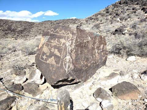
Photo: Petroglyph National Monument, Albuquerque, NM.
What are National Parks? What makes them different from National Monuments and National Historic Sites?
The most well-known of America's public lands, the lands managed by the National Park Service (NPS) are the original public lands, beginning with Yellowstone National Park's establishment in 1872. These lands are generally under stricter protections than most other agencies, as they protect "expanses or features of land or water of great scenic and scientific quality." The NPS is under the Department of the Interior, along with the Bureau of Land Management.
Like the National Forests, there are of course several designations that account for different resources being managed by the National Park Service:
- National Parks protect a variety of natural and cultural resources, generally of a larger land area.
- National Preserves and Reserves are areas set aside for the protection of resources. These areas have much overlap with what qualifies for National Park status, but these lands are generally less restrictive (allowing hunting or leases for economic activity). Valles Caldera National Preserve in New Mexico is administered by the NPS, but allows hunting and other activities that a National Park would not.
- National Lakeshores and Seashores are areas protecting natural resources in lakes and oceans, similar designations to National Parks.
- National Rivers are similar to Wild & Scenic Rivers, but are managed by the NPS and offer developed recreation in addition to natural resources.
- National Historic Sites encompass a wide range of areas protected for their historical value; battlefield sites, military history sites, and other small-scale areas of historic importance. A vast majority are officially under the National Park service, but several are administered by other agencies.
- National Historical Parks are more extensive than historic sites; they are often areas that have been inhabited over a long period of time or have multiple historic buildings or sites in its boundaries.
- National Memorials are areas created to commemorate a specific person or groups of people important to history.
National Monuments are a unique designation, in that any federal agency can be responsible for their management. Created by legislative action or by presidential decree, National Monuments extend formal protections to lands already under federal jurisdiction and often limit activities that could be destructive to the natural and cultural resources on these lands. Each monument is unique in its creation, recreation opportunities, and management.
For example, northern New Mexico's Río Grande del Norte National Monument was created in 2013 by presidential proclamation, and is managed by the Bureau of Land Management. It's boundaries contain a checkerboard of BLM, state, and private lands. Hunting, dispersed camping, and many activities allowed on other BLM lands are generally allowed on the BLM lands within the monument (outside of specified recreation areas [more below]). Essentially, the monument designation applies only to the federal lands within this area, and not state or private land.
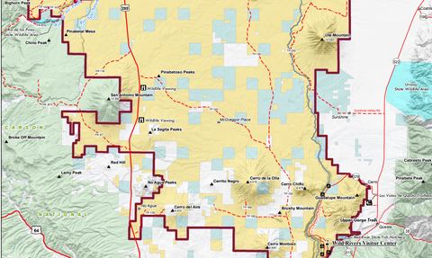
Northern portion of the Río Grande del Norte National Monument. Boundaries of the monument are in purple. Notice the BLM lands (yellow) intermixed with New Mexico state trust lands (blue) and private land (white). (Source: NM Bureau of Land Management).
Meanwhile, the nearby Bandelier National Monument was created through legislation in 1916, and is managed by the National Park Service. All the lands within its boundaries are fully administered by the NPS, and activities like hunting and target shooting are totally restricted there, as is camping outside of developed campsites without a permit.

Bandelier National Monument boundaries (green). Notice the two separate units. Both are entirely managed by the National Park Service, with no other lands intermixed. (Source: National Park Service)
As always, it's best to Know Before You Go—call the appropriate agency office or visitor center to get the most current and accurate information. To sum things up: every National Monument is a case-by-case basis in terms of what agency is managing its land and what is allowed there. The main commonality is that these lands are reserved for the protection of "historic landmarks, historic and prehistoric structures, and other objects of historic or scientific interest that are situated on land owned or controlled by the Federal Government" (1906 Antiquities Act).
What's a National Historic Trail? What about National Scenic Trails?
Long-distance National Scenic Trails like the Appalachian or Continental Divide Trails are designated due to their scenic and recreational value to the nation. They wind through some of the most well-known landscapes in the country and through lands managed by various agencies.
National Historic Trails aren't necessarily physical trails, but trace the route of historic roads and travel events. Many modern roads cover portions of these trails, while some spots are still narrow hiking trails. This is mainly a symbolic designation, but some specific sites tied to their history are preserved as Monuments or Parks.
What are National Recreation Areas?
National Recreation areas can be administered by any land management agency, and are generally areas dedicated to developing recreation infrastructure. The boundaries are created by acts of Congress. Some areas of National Monuments and National Forests have this designation, like the Orilla Verde and Wild Rivers Recreation Areas within the Río Grande del Norte National Monument.
Photo: Lower Gila Box Wilderness Study Area, NM (BLM, Public domain).
What is BLM land? What does the Bureau of Land Management do?
The Bureau of Land Management (BLM) is a federal agency under the Department of the Interior, just like the National Park Service. While all National Park lands are held for conservation purposes though, many BLM lands are open to commercial access and a wider variety of recreation activities as well. This agency began life as the General Land Office in 1812, which kept records on the homesteads and rapid exchange of federal and private property as the U.S. expanded west. In 1946, the U.S. Grazing Service was merged with the General Land Office, creating the BLM.
Many BLM-managed lands tend not to be as impressive as National Parks, but the vast areas of land they do manage are vital to many industries and wildlife species. The BLM does some work similar to the National Park Service though, such as managing the Río Grande del Norte National Monument in New Mexico.
Generally, BLM lands are some of the least restrictive in terms of recreation, offering many opportunities for hunting, camping, and fishing away from developed recreation sites (and often without fees). Small numbers of developed recreation areas and historic sites do fall under the BLM, though.
In managing these lands, the BLM, like the Forest Service, also falls under a multiple use mandate, meaning that recreation, commercial, historical, and ecological needs of public lands are given consideration. They also manage below-surface mineral rights for mining.
Because of their broad purview, the BLM can generally be thought of as the "catch-all" for public lands that don't fit the more defined definitions of National Forests/Grasslands or National Parks.
The BLM only has a handful of other designations for their lands:
-
Special Recreation Management Areas (SRMA) are set aside with specific plans to accommodate or support different forms of recreation. These can be Off-Highway vehicle areas with specific trails, a set of hiking or biking trails, or equestrian infrastructure for horseback riding, among other things.
-
Wilderness Study Areas (WSA) are roadless areas that are currently under consideration for wilderness status. Depending on the area, certain restrictions may be in place to preserve the area as best as possible. Eventually, these lands may be adopted into the Wilderness Preservation System, or simply left as standard BLM lands without the designation of Wilderness, National Monument, or other protections.
-
Areas of Critical Environmental Concern (ACEC) can denote special management needs for a variety of purposes, but they tend to be some of the most restrictive BLM lands. These can be designated to protect at-risk species, delicate historical resources, or to prevent injury with hazards such as abandoned mines. Access to these areas can vary; many are open to the public, but have a gate (which can be opened with a quick call to your local BLM office), while others are generally not separated from other BLM land. A BLM land status map is helpful in identifying these areas.

Photo: Bosque del Apache National Wildlife Refuge, New Mexico (public domain).
What are Wildlife Refuges? What are the purpose of National Wildlife Refuges?
Under the Department of the Interior, the U.S. Fish & Wildlife Service (USFWS) is tasked with tracking and providing protection for endangered species, as determined by the 1966 Endangered Species Act. Federal lands given to this service are generally used to restore and provide habitats for species that meet those criteria.
While endangered species are a top concern, the health of the ecosystem at large is also their responsibility. Many of the lands under this agency are prime destinations for hiking, birdwatching, hunting, and fishing; though some areas are more restricted than others. National Wildlife Refuges can then be thought of as a public land where all activities are primarily concerned with the health of wildlife populations and habitats.
The USFWS works closely with state game and fish departments to conduct hunts, maintain accurate estimates of populations, and put Wildlife Refuges in a state-wide context.
So what about state lands? Are state parks and state forests part of National Parks or National Forests?
All the lands discussed above are at the federal level. Their lands (in addition to some branches of the military and the Army Corps of Engineers) make up a vast majority of public lands in many states.
Each state has a unique relationship to the federal government in terms of State-owned lands. Some states like New Mexico have a significant portion of its land set aside in "state trust", while others have little non-federal land that isn't privately owned. Ultimately, the state government is responsible for managing state trust lands and state parks, and determining how they are used. Regulations, rules, and management philosophy will vary significantly when travelling into different states.
In New Mexico, recreating on State Trust Lands (outside of State Parks) require a yearly pass to access legally. The state also holds rights to lease and sell this property as they see fit, marking a large difference from federally protected lands, which usually have restrictions on boundaries and economic rights signed into law.
State parks are modelled on the National Park System, and are generally accessible for recreation (usually for a fee). State forests and recreation areas fall into this category as well, and are usually geared toward recreation and tourism than economic purposes. Details will vary greatly state-to-state.

Photo: Boundary between Kaibab National Forest and Grand Canyon National Park (public domain).
Why should I care what public land I'm on? Aren't all public lands the same?
Just as you're responsible for hunting within the boundaries of your unit, you're responsible for understanding the rules when recreating on public lands. Sometimes, rules that apply to one agency's lands aren't applicable to neighboring ones.
Most importantly, keep in mind that:
The Western U.S. is a checkerboard of private and public lands.
Outside of large National Park Service lands and National Forests, you're unlikely to encounter large, unbroken pieces of land. Keeping track of the countless resources of all types on these disconnected lands is a daunting task, and understanding the rules and regulations of the land you're on can help make their management easier.
Data is a valuable resource to all of these agencies, and constant monitoring of conditions contributes to the long-term understanding of these lands and how they provide for us.
It is always best to reach out to a ranger station or office before you set out to recreate on public lands! Even if you're traveling to a highly-trafficked recreation site, they can fill you in on the best areas to go to beat the crowds, key you in to closures and restrictions in the area, and be another individual who knows where you are going!
Many recreationists each year skip this step and become lost or injured. It's always better to Know Before you Go!
Helpful links:
- US Forest Service: fs.usda.gov
- Bureau of Land Management: blm.gov
- National Park Service: nps.gov
- US Fish & Wildlife Service: fws.gov
- WildernessConnect: wilderness.net
- Leave No Trace: lnt.org

0 comments